Colorado River Environmental Issues
 The river itself is apportioned to the previously mentioned seven states and Mexico as shown in Chart 1:
CHART 1
(US Department of the Interior Reclamation Bureau, 1971 - 2005 [USDIRB])
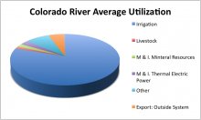
The use of the Colorado River is diagrammed in Chart 2.
CHART 2
The ecology and geology of the river varies by region. The rock is generally shale and sandstone, with appreciable soluble mineral content. In the event of weathering or irrigation, salts may accumulate on the surface. This salt accumulation can also be due to consumptive use by plants and evaporation. The geology includes bedded and disseminated sodium chloride - halite, calcium sulfate - gypsum, limestone, shale, and granite (Patrick, 2000, 8). The ecosystem around the river is home to 1, 400 species of vegetation (Patrick, 2000, 10) - both native and invasive, salamander, five species of toads and frogs (Patrick, 2000, 10), the Grand Canyon Rattlesnake, several species of lizards, 303 avian species - including the bald eagle and peregrine falcon, and beavers (Patrick, 2000, 11). The Grand Canyon is the only river system with appreciable increase, rather than decrease in riparian vegetation and animal populations (Patrick, 2000, 12). Therefore, it is extremely important that these habitats be preserved, and that the use of the river is improved so that human demands do not negatively affect the Colorado River ecosystem.
 The Colorado River water in the United States is governed by a variety of legislative documents. The oldest and most important of these is the Colorado River compact, which apportioned the river as seen in the images above. It divided the basin into its Upper and Lower regions, with the dividing line found at Lees Ferry, Arizona, downstream of the Glen Canyon Dam. This compact was signed in 1922 (Anderson, 2004, 78). Following the Colorado River Compact was the Boulder Canyon Project Act (1929). Essentially, this act reinforced the apportionment in the Colorado River Compact and provided for the creation of the Hoover dam and the All American Canal, which brings water to the Imperial Valley in California, the state receiving the majority of Colorado River water. Although this act was passed, the lower states, Arizona, Nevada, and California, could not come to an agreement as to the apportionment of the water in the lower basin (Anderson, 2004, 78). This led to the 1963 Arizona vs. California Supreme Court decision.
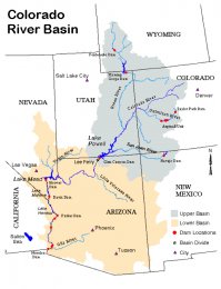 This decision finalized the distribution of water from the river, and ensured Arizona that its use of the Gila River would not diminish the amount of Colorado River water the state received (Anderson, 2004, 78). Prior to this agreement in the Lower Basin, the Upper Basin states signed the 1948 Upper Colorado River Basin Compact. This compact resulted in the distribution of Colorado River water among the four Upper Basin states, which are Colorado, Wyoming, New Mexico, and Utah. The final apportionment is seen the table above (Anderson, 2004, 79). One of the most recent legislative documents concerning the river is the Interim Surplus Guidelines (2001) (Anderson, 2004, 79). This document allows the Secretary of the Interior to meet the industrial and municipal demands in the Lower Basin, during the time period between 2001 and 2016, when reservoirs were projected to be relatively full.
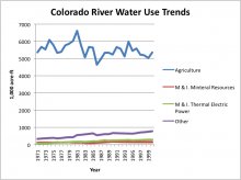 It also allowed for California to reduce its dependence on the Colorado River by 800, 000 acre feet annually, since California had been using 5.2 million acre feet, 800, 000 over its allotted 4.4 million acre foot annual allocation. These provisions were structured to ensure the protection of the other basin states in times of drought. It also allows Arizona and Nevada the right to use surplus water, in addition to California (Anderson, 2004, 80). The most recent, and final legislative document pertaining to the river is the Quantification Settlement Agreement, signed in 2003. This agreement states that California must adopt measures to reduce its demand to at least the 4.4 million acre foot allocation it is allowed. It also allows the transfer of historical irrigation water from the river, in the Imperial Valley and Palo Verde area to growing municipal and industrial areas in Southern California, whose demands are growing. Additionally, it provided a program to reduce salinity levels in the Salton Sea, and provided $163 million to help reduce this salinity, and also to improve the environment in the Imperial Valley. Lastly, it provided for the lining of the All American Canal, (the water saved from this lining is sold to San Diego) and described the allocations of Colorado River water to individual water user entities in California (Anderson, 2004, 80).


